Hurricane Patricia is predicted to disperse well before reaching the United States. However, remnants of the massive storm that is currently hitting Mexico may drop heavy rains in Texas this weekend until early next week. Texas, along with other southern states, are already being soaked by a separate storm system.
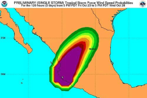
The Category 5 hurricane is reportedly the strongest to hit the Western hemisphere with maximum sustained winds of 200mph. According to the National Hurricane Center's (NHC) latest statement, Patricia has made landfall at approximately 6:15 p.m. CDT along the coast of southwestern Mexico near Cuixmala.
The hurricane continues to move farther inland with a speed of 15mph (24km/h) and follows a north-northeast direction. About an hour after making landfall, the storm reportedly lost force and its winds slowed to about 130mph. It was also downgraded to Category 4 and the NHC forecast that Patricia would eventually weaken to a tropical storm by Saturday morning and a tropical depression by Saturday afternoon, according to the New York Times.
Though it is not expected to pose a serious threat to the U.S., the hurricane does come on the heels of a separate storm system that has already been pouring down heavy rains in Texas and neighboring other states on Friday, increasing the risk of flooding.
Hurricane Patricia's potential path across the US includes the western and southern counties of Texas, and parts of Louisiana and Arkansas. While its winds will likely weaken, the threat for flash flooding is expected to worsen this weekend as the slow-moving storm system is aggravated by the moisture-laden air from the Gulf of Mexico.
The National Weather Service has issued Flash flood watches for much of Texas, including the Dallas-Fort Worth metropolitan area. These watches were recently expanded eastward into portions of Louisiana.Weather forecasters said that large areas of Texas can expect up to a foot of rain as Patricia's remnants pass through the state on Sunday and Monday.
In the wake of the life-threatening hurricane, the U.S. Department of State has released a safety advisory informing citizens in the hurricane warning area (primarily in Mexico) to take precautionary steps.
The department advised U.S. Citizens to take shelter and monitor media reports about the status of the storm. They can listen to the local radio or check with the check updates from the National Weather Service or from Mexico's Servicio Meteorológico Nacional to stay aware of weather developments. Americans in the hurricane warning area can also check the goverment's Protección Civil website for official instructions and updated information about the storm.
As hurricane Patricia moves inland, it will continue to produce heavy rainfall and and strong winds. As such, it may cause dangerous conditions that result to flash floods, flying debris and power line interruptions. People are advised to stay clear of downed power lines to avoid accidents. Furthermore, the advisory also called for people to avoid staying near beaches due to risks of storm surges and life-threatening surf and rip current conditions.


