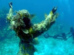
Oceanographer Paul Snelgrove said once that we know more about the Moon and Mars than we know about the Ocean. Well, Google wants to change that, and this week they have a team of scientist in the Florida Keys with special fisheye cameras to map the reefs and other wonders of the deep.
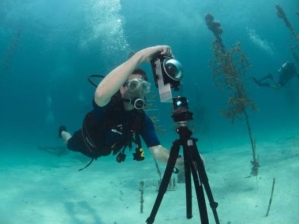
According to the Associated Press, U.S. government scientists are learning to use special equipment designed for underwater mapping in hopes of applying "street view" technology to research and management plans in marine sanctuaries nationwide. Some of the rotating and panoramic images will be available online as early as this week, including a selection on Google Maps, giving the average joe a look into ecosystems very difficult and expensive to explore in other ways.
The cameras they are using resemble the basketball-shaped, triple-lens SVII cameras which use the same technology used to produce Google Street View images on land.
Google hopes the effect produced will give the viewer the sense that they are scuba diving without getting wet.
Each camera rig weighs over 140 pounds, which is much lighter than the land based units, but the scuba-diving scientist still have to use small motors to help them glide through the water.
If you are familiar with street view mapping, then you know the tech also uses GPS technology and weaves the images together to render the world in a full 360 degree picture.
Google is not the only group funding the venture, as they have partnered with the Catlin Seaview Survey, funded by the global insurance company Catlin. The images that have been produced so far from other Catlin surveys are being uploaded online to the Catlin Global Reef Record.
About 400,000 images have been compiled so far from reefs in Australia and the Caribbean, according to the AP.
While the main survey continues worldwide, smaller cameras will be available for targeted projects within NOAA sanctuaries, such as gauging the effectiveness of preservation zones in California's Monterey Bay sanctuary, or they could help measure the impacts of landslides that fall into the water.